
Forecasting Damage with the Modified Mercalli Scale
The Modified Mercalli Scale (MMS) uses fault proximity and soil type to assign a house a certain shaking zone. In the 1996 study Shaken Awake! financed by the National Science Foundation, scientists looked at damage from both the Northridge and Loma Prieta Earthquakes to forecast probable damage to the Bay Area’s housing stock when the Hayward Fault ruptures using the Modified Mercalli Scale. This study helps emergency planners prepare for anticipated peak shelter levels.
Each zone in the Modified Mercalli Scale represents a degree of shaking intensity. Understandably, the amount a house shakes determines how much damage there will be. The relevant shaking zones in the MMS for the Bay Area extend from severe shaking (zone VIII) to extreme shaking (zone X+).
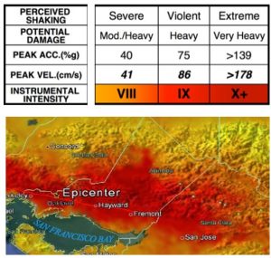
SHAKING INTENSITY AND MERCALLI SCALE
The USGS predicts a large 6.8-7.0 earthquake on the Hayward Fault. Once a conversion is made from Richter Scale (Magnitude 6 to 7 in the table below) to the Modified Mercalli Scale, the result is MMI zones VIII and IX for most houses within a few miles of the fault. Houses within a few yards of the fault are in zone X+.

COMPARISON OF RICHTER AND MERCALLI SCALES.
What is Red-Tagging?
Red-tagging is when a local building department places a red notice on your door declaring your house unsafe to enter. You must correct the dangerous conditions to get the tag removed.
According to a report published by the Association of Bay Area Governments, houses built before 1940:
- In MMS zone VIII, 1.8% will be red-tagged
- In MMS zone IX, 8.4% will be red-tagged
- In MMS zone X+, 12% will be red-tagged

PERCENTILE OF BUILDINGS RED-TAGGED IN SEISMIC ZONE IX.


